
Mineral exploration intelligence for AfricaData. Insight. Precision.
Satellite-Based Mineral Exploration Intelligence for Africa
Xidar helps exploration teams, investors, and project developers use satellite data, structural interpretation, and GIS evidence to screen licence areas, rank exploration targets, and plan field validation.
Remote sensing. Prospectivity mapping. Field-ready targets. Decision-grade reporting.
Canada-based governance. Africa-specialized execution. Focused on the Horn of Africa and Arabian-Nubian Shield.


Operating Footprint
Africa-facing satellite intelligence with international coordination nodes.
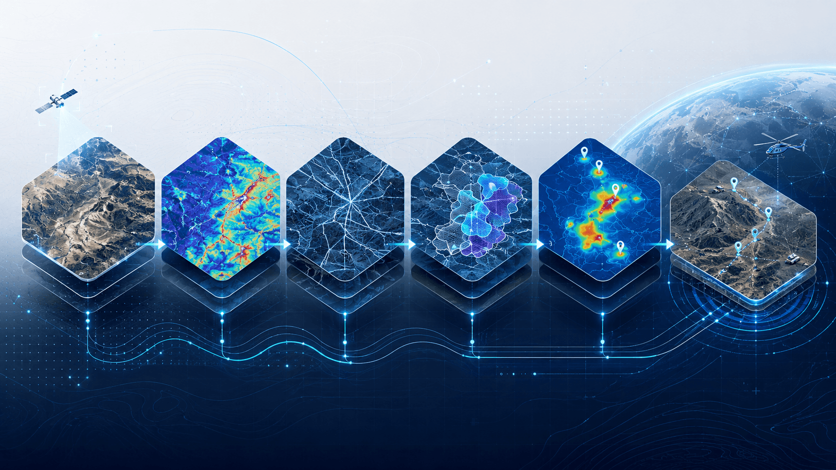
01Desktop GIS & spectral remote sensingSatellite imagery, terrain models, and regional datasets are reviewed to define the technical evidence base.
02Prospectivity modelling & target rankingAlteration, structure, terrain, and geological context are combined to identify priority zones.
03Field verification & structural mappingRanked targets are translated into field-checking priorities, mapping routes, and sampling logic.
04Laboratory integration & QA/QCField observations and sample results can be integrated into the evidence chain to strengthen interpretation.
05Decision-grade outputsFindings are delivered as maps, GIS files, target cards, executive summaries, and technical notes.
Exploration intelligence pipeline
From satellite evidence to field-ready decisions.
Xidar turns fragmented geospatial and geological data into practical exploration outputs. We help teams understand where the strongest evidence is, why a target matters, and what should be validated next.
01
Satellite imagery
Multisource orbital and terrain datasets define the first technical reading surface.
02
Spectral alteration
Clay, iron oxide, silica, vegetation, and hydrothermal proxies are screened for relevance.
03
Structural evidence
Lineaments, corridors, intersections, and terrain breaks sharpen mineral-system hypotheses.
04
Evidence stacking
Independent evidence layers are combined to show where multiple indicators converge.
05
Prospectivity ranking
Targets are ranked by evidence strength, uncertainty, field practicality, and project objective.
06
Field validation plan
Outputs are converted into field priorities, sampling logic, target cards, and decision-support reporting.
Regional operating model
Global governance. Regional intelligence. Local execution.
Xidar’s coordination footprint connects international technical standards with regional understanding across Africa and key investor-facing markets.


Operating Footprint
Locations describe Xidar’s operating and coordination footprint for homepage context. They should not be read as legal office status unless separately verified.1
Toronto
Canada
Governance, advisory oversight, and investor-facing coordination.
2
London
United Kingdom
Technical-commercial positioning, investor engagement, and international coordination.
3
Bristol
United Kingdom
Geospatial, research, and technical collaboration support.
4
Dubai
UAE
Regional partnerships, business development, and cross-border delivery support.
5
Hargeisa
Somaliland
Horn of Africa coordination, field logistics, and local intelligence.
6
Addis Ababa
Ethiopia
Regional geospatial and structural analysis support.
7
Mogadishu
Somalia
Field support, stakeholder coordination, and local engagement.
8
Lusaka
Zambia
Southern Africa exploration support and programme reach.
Governance discipline
Structured oversight, transparent delivery standards, and clear technical accountability.
Regional familiarity
Better understanding of terrain, access, stakeholders, field conditions, and local operating realities.
Faster mobilisation
A smoother transition from desktop analysis to practical field follow-up.
Investor-ready delivery
Clearer outputs for exploration managers, investors, boards, and technical reviewers.
Evidence fusion engine
Spectral, structural, terrain, field, and lab evidence in one chain.

Evidence Chain
Each evidence layer has a role: reveal the signal, test the structure, understand constraints, and support field-ready prioritisation without overstating certainty.
Evidence
Alteration evidence
Spectral proxies help flag clay, iron oxide, silica, and hydrothermal patterns worth technical review.
Layered intelligence
Evidence
Structural evidence
Lineaments, intersections, and corridor geometry help explain why a target may matter.
Layered intelligence
Evidence
Regional geology
Shield-scale context keeps local anomalies connected to broader mineral-system logic.
Layered intelligence
Evidence
Terrain/access constraints
Relief, drainage, access routes, and operating realities shape which targets can be validated first.
Layered intelligence
Evidence
Field validation
Priority areas are framed so field teams can test desktop interpretation efficiently.
Layered intelligence
Evidence
Lab / QA/QC
Sampling and assay review close the loop between mapped evidence and technical confidence.
Layered intelligence
Sample outputs
Technical outputs designed to make exploration evidence easier to act on.
Xidar deliverables are structured to help teams understand where to focus, what evidence supports each target, and what should happen next.
Desktop interpretation is a decision-support tool. Field validation, sampling, lab analysis, and qualified technical review are required before operational, investment, or disclosure decisions.
Clarity
See what matters.
Intelligence
Evidence-led analysis.
Precision
Focused target logic.
Velocity
Faster screening cycles.
Trust
Repeatable reporting discipline.
Next step
Turn exploration data into field-ready decisions.
Submit an area of interest, target commodity, project stage, and available datasets. Xidar will review the scope and help define the right assessment pathway before formal engagement.
Outputs are structured to support technical diligence and can be formatted for review by a Qualified Person or Competent Person where formal disclosure is required.